This is an early version of the ACLED dataset, originally a joint PRIO project, but now a separate project.
The ACLED dataset codes exact locations, dates, and additional characteristics of individual battle events in states affected with civil war. There is a specific focus on tracking rebel activity and distinguishing between territorial transfers of military control from governments to rebel groups and vice versa, and the location of rebel group bases, headquarters, strongholds and presence. The dataset also records one-sided violence on civilians by both government or rebel actors and conflicts between rebel groups. The conflicts coded for in the dataset are in general compatible with the Uppsala/PRIO armed conflicts.
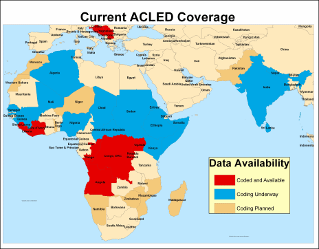
In this version, the dataset covers 8 conflict countries in West and Central Africa from 1960 through 2004. ACLED's disaggregation of civil war and transnational violent events allows for research on the local level factors and dynamics of civil conflict.
The dataset is part of the larger GROW-Net project, which aims to supplement the study of civil war with models and data that refer to other geographical units than the state. Creating a dataset that codes the specific geographic location of armed conflict events will allow for both focusing at small-scale behavior and compiling information for larger geographical units that do not coincide with national boundaries.
Countries completed in dataset
- Uganda
- Rwanda
- Burundi
- Democratic Republic of Congo
- Angola
- Republic of Congo
- Liberia
- Sierra Leone
- Croatia
- Serbia
- Macedonia
- Kosovo