Civil wars cluster around the Equator – but why?
Posted Friday, 4 Sep 2026 by Halvard Buhaug, Nils Petter Gleditsch & Andreas Forø Tollefsen

Civil wars cluster in space. Large parts of the earth have been spared organized violent conflict, while other regions have been less fortunate.
As the Figure shows, civil war events were overrepresented in 2025 around the Equator. A particularly large number of violent events were found in Africa just North of The Equator, with a second peak somewhat further North in Afghanistan, Iraq, and Syria. In the Americas, the only violent events were found in Colombia, which straddles the Equator. Over the three decades 1991–2021, the share of countries with at least one civil conflict declined steeply as a function of latitude. This pattern has remained stable since decolonization began in earnest in 1960. The typical conflict-affected country has consistently been located closer to the Equator than the average country at peace.
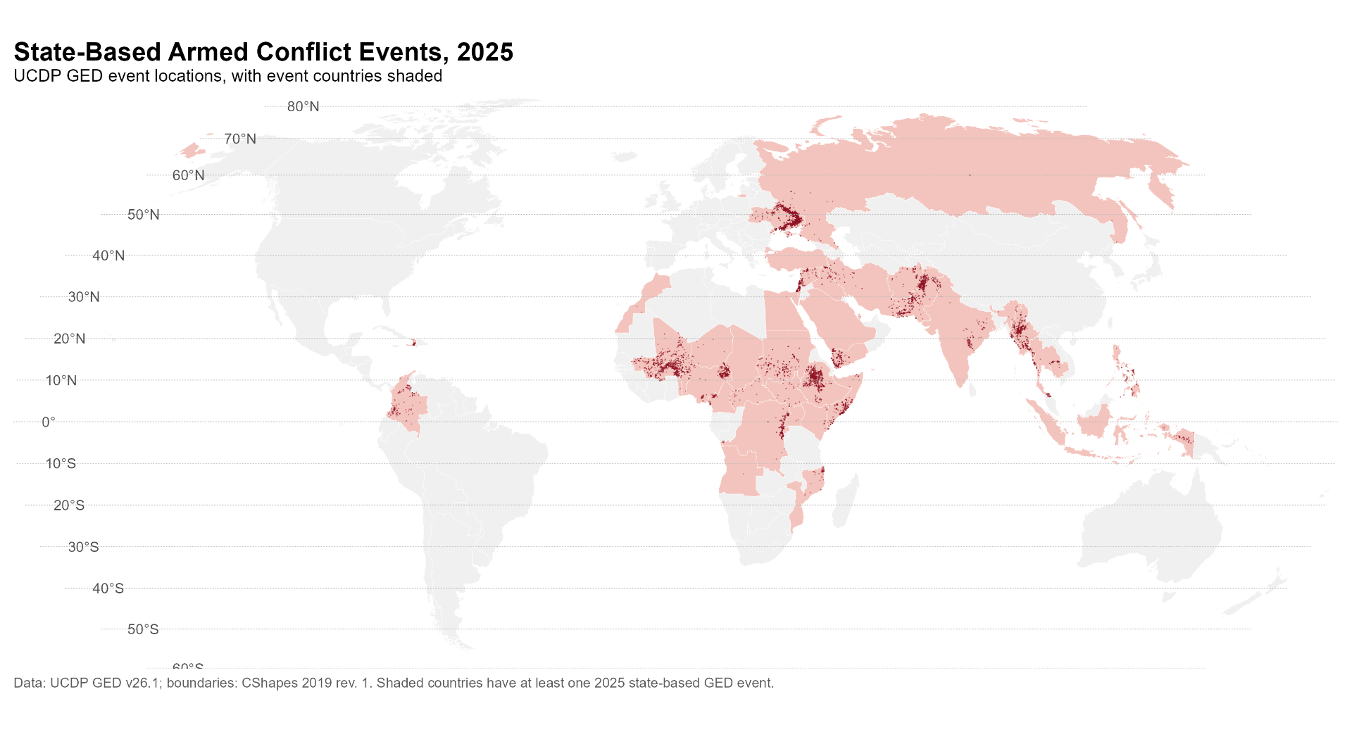
The geographical clustering of conflicts has been documented in previous research. But why do conflicts cluster around the Equator? Latitude has been found to correlate with a variety of behavioral outcomes, including outgroup discrimination, aggression, and interpersonal violence, but the relationship between latitude to armed conflict has not been studied previously.
A direct causal link between latitude and armed conflict does not seem plausible. In our study, we investigated three broad explanations for the spatial distribution of civil war rooted in underlying environmental and geographical conditions: climate (temperature, climate zone), geography (mountainous terrain, landlocked), and the age of the first settlement. All of these are related to latitude but are not influenced by armed conflict. When we control for these three factors and for conflict history, the significance of latitude is reduced somewhat but not eliminated.
Next, we control for a number of factors commonly associated with civil war, such as population size and density, ethnic diversity, Muslim share of population, former colony, democracy, and development (as measured by child mortality). Many of these factors also cluster around the Equator. Most of them, when introduced in the analysis, reduce the effect of latitude. When democracy and child mortality are included, latitude is no longer significant. However, these factors are themselves likely to be influenced by the presence of armed conflict, so we cannot take the direction of the causal influence for granted.
As noted, we do not find it plausible that the distance from the Equator should have a causal direct influence on conflict risk. The lack of a significant relationship between latitude and conflict when controlling for democracy and development hints at possible causal mechanisms. One plausible interpretation is that latitude shapes environmental conditions, notably climate, which in turn facilitates or constrains political, social, and economic outcomes, and thereby latent conflict risk. This is consistent with our data, but they are also consistent with alternative storylines.
- Halvard Buhaug, Nils Petter Gleditsch & Andreas Forø Tollefsen (2026) Conflict by latitude: Disentangling the spatial clustering of civil war. Conflict Management and Peace Science, doi: 10.1177/07388942261458225, https://www.prio.org/publications/14826.
Related comments





Related topics
Conflict TrendsAll tags